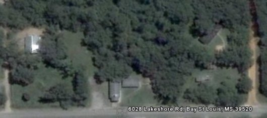
Sort of just for fun, I imported a list of all the sister churches in our Gulf Coast Baptist Association into Google Earth. Download and install the free Google Earth application. Open the gcba.kmz file and fly to the Mississippi gulf coast. You will see place markers for all the SBC churches in our association. If you navigate to our church, you can view the satellite imagery of our buildings from before the storm. I inserted a couple of before and after Katrina pictures of our buildings.
I plan to compile a list of the 300, or so, churches that have made mission trips to Lakeshore since the storm and import them into Google Earth to create a nation-wide map of the volunteers who have come from across the country. I’ll post it when I have this map together.


5 Comments
That would be COOL to see when you get it done, Don.
We always enjoyed looking at the map of the States in the mess hall to see which states had been added with the stick pins. We didn’t see it however last time.
Good luck w/ your project!
Don,
How old is that aerial?
I do not know. Its pre-storm. I guess probably 2004. I posted the post-storm imagery today.
It is amazing to see the thickness of the trees.
That is Chip’s house in the left background
where the mess hall now stands, right? wow!
Yes. That is Chip’s house at the top left of this screen-shot.
I wish we could get an aerial photo of what the camp site looks like now.